
The Basics
Vector Aerial Imaging is a multi faceted company that provides aerial photography, video and data for clients in central Texas and world wide. Our pilots are highly trained, fully FAA licensed, and safety conscious professionals. We have OSHA certifications for various projects. We can provide stunning 4K video for your project or personal use.
We use state of the art quad-rotor drones to get the best images of what you need. These are powerful, FAA licensed aircraft. They can reach over 18,000 feet above mean sea level, and have control and live video at over 3.5 miles. We keep a live feed in HD as we progress through the flight, and have on-board recording capabilities that capture 4K video.
We strive to produce beautiful, cinematic quality videos and photos for your projects. The quality is the best in the market - we can help you sell your project, listing or service. The finished videos are awesome and there is no better way to promote your business.
We can produce an image that has resolution of 1 cm per pixel of your entire property or job site. Satellite maps provide this - true, but at a resolution of about 4-6 feet per pixel. We can give you over 85 thousand times clearer images. Let us know how detailed of an image you need, and we can produce it.
Do you need a 3D photo-realistic model of a place? We can duplicate buildings, job sites and surveys with state of the art photogrammetry that is geo-referenced through US and GLONASS satellites simultaneously, giving you unparalleled views.
Do you want to monitor crops for water retention, health or fertilizer needs? Ask how we can help in a fraction of the time.
Do you need to inspect a place that is hazardous or difficult to get to? We can fly up and get you eyes on site in no time, with the ability for you to inspect in real time what is going on at the location with less risk of damage to property or injury to personnel.


FILM
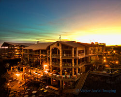
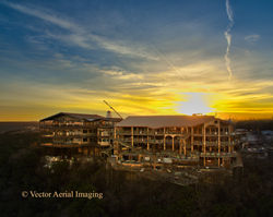
We work with commercial clients to provide that special pop and wow factor that aerial shots can provide. We can edit a presentation for you, or provide raw footage for your use. We can help realtors, engineering firms, building project managers. Call us to see what we can do for you.
Our photography services are unmatched in quality Both SLR and aerial photography can benefit your project or next sale. We can provide interactive images that allow your clients to "put themselves in the scene". Imagine being suspended 200 feet up and being able to look all around - we can make that happen for you. Virtual staging is something that we can also provide.
Do you need a unique perspective? We have the tools and talent to make it happen.
 |  |  |
|---|---|---|
 |  |  |
 |  |  |
 |
Double Click to see full images
COMMERCIAL
Realtors, contractors, inspectors, roofers, industrial plants, engineers, hotels and resorts, agriculture, golf courses.... many can benefit by saving money and time from our affordable, reliable services! Call us to find out how.
We help speed up inspections by putting your personnel safely on the ground with eyes in the clouds. We can go into places that are dangerous or time consuming to get to in a fraction of the time with minimal risk. They can get a real time look at areas and closer looks at areas they want to see.


So are you a home owner? Need to get your roof or house inspected? We work closely with inspectors for the best possible images of those hard to get to, dangerous or easily damaged places, saving you time, money and risk.
Are you a hunter? We can provide detailed surveys of your hunting area. Would you like to have an image that has resolution of 1/4" per pixel of your entire lease? No other platform can provide as detailed of an image as we can. You will be shocked at the amount detail we can get you.
Individuals


5800 Brodie Ln, #1138
Austin, TX 78745
Filming, Photography, and Photogrammetry for your needs. Work smarter with us.

REC